
Exploring the bittersweet relationship of schools’ closure and smog
March 4, 2024
Population in Pakistan and Data: An Overview
March 5, 2024Exploring the bittersweet relationship of schools’ closure and smog
March 4, 2024Population in Pakistan and Data: An Overview
March 5, 2024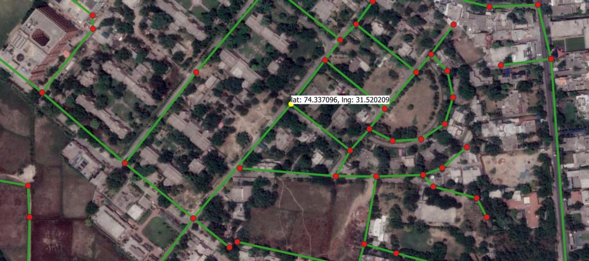
Extracting Road Network of Lahore from Open-Source Imagery
1 Road Network
A road network is a collection of nodes and edges, much like any other graph. Junctions and roadways are represented by nodes and edges, respectively. A straight road has only two nodes at the beginning and end, but a curved road may contain additional nodes (not representing junctions) that aid in the tracing of road segment shapes. Unlike other graphs, each node is given a latitude and longitude to indicate where it is on the earth’s surface. A sample road network is shown in figure 1. The intersections are represented by the red dots (nodes), while the roads are represented by the green lines (edges). Each node has longitude and latitude; however, I’ve only shown the coordinates of one (yellow) node in this diagram.
Figure 1: Sample road network.
2 Importance of Road Network
The road network of a region is critical because it is a crucial component of almost all sorts of urban planning and policy study. Developed countries build and maintain a detailed road network in which each road segment (edge) is associated with various attributes like width, type, construction material, direction, speed, etc. A handful of the many uses of the road network are listed below.
2.1 Finding Shortest Path
The popularity of online shopping, ride-sharing, and online meal delivery applications has exploded in recent years. For services such as tracking and shortest path finding, all organizations in these domains rely substantially on third par- ties (such as Google). These services consume a significant percentage of their budget which can be avoided by using road network. Logistic companies such as TCS, M&P, Leopards Courier, DHL, and FedEx can use road network and reduce the cost spent for the services availed from third parties. Similarly, meal delivery companies like Foodpanda, Cheetay can use it for their benefit. Ambulance services rely heavily on their ability to respond quickly. They need to go to the accident site as quickly as possible, and there is sometimes a lag in response when using third-party services due to network issues. Therefore, ambulance services like Rescue 1122 and Edhi can incorporate road network to improve their services.
Traffic Congestions Inference
Due to the multifaceted dimensions of our data, we needed a base variable that would act as a source of reference for comparison. Since we wanted to compare travel time variations, we first normalized these travel times by converting them to respective velocities (route distance divided by travel time) for each data row. This step enabled us to visualize variations in velocities.
Next, we decided to use Sunday’s velocities as the base values. As a result, we were able to compare the velocities for Mondays and Weekdays with respect to Sundays (common denominator) in the form of a percentage difference.
This percentage difference in velocities, for the purpose of this write-up, is being represented in the form of traffic congestions i.e., the greater the percentage difference in velocities from Sundays, the greater the increase in traffic congestions. Going forward, our team will be incorporating additional dimensions to this dataset with the ambition of analyzing the complexities involved in traffic mobility on a city level.
From this point onwards, our analysis will be based on traffic congestions for each route. After some data preprocessing steps, we directed our attention towards the insights that may be drawn from our database.
Data Insights
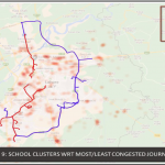
As the focal point of our study was centered around a data-driven analysis regarding the closing of schools on Mondays, we have first presented our results on a city level. Next, we decided to delve deeper into this problem by identifying the most congested routes. These routes were then mapped onto a schools heatmap to determine any causality between the proximity of a route with nearby schools.
2.2 Travel Time and Distance Estimation
The estimation of travel time or distance by road between two sites on a map is one of the most popular uses of a road network. Various tools, such as ArcGIS and QGIS, take a road network as an input and produce the desired output. The procedure for estimating travel time and distance between places is detailed in the figure 2. The network analyzer tool is given the road network as well as the source and destination points. The tool calculates the shortest route between these two points. The length of the path is then calculated, which is equal to the distance between the points. Each edge must have a speed attribute to calculate transit time. The speed and distance of that particular edge are used to compute the time spent on it. The predicted journey time is the sum of the time spent on each edge.
One may argue that the same output can be obtained using Google Maps. But there are various limitation imposed by the Google Maps. First of all, using Google Maps, one can find the travel time and distance for only two points at a time. If you want to find the travel times between thousands of points at a time, then it is not possible using Google Maps. Google Maps do provide an API using which you can run a loop for each possible pair of points, but it is not free. Therefore, in such cases road network is very useful.
2.3 Testing of Shortest Path Algorithms
In everyday life, the topic of determining the shortest path between a given source and destination point is frequently addressed. Companies in the logistics and traffic control industries must do these calculations on a large number of
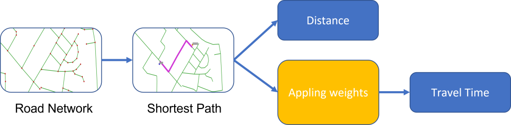
Figure 1: Sample road network.
points. As a result, to reduce computing time, it is necessary to improve the techniques used to find the shortest path. Dijkstra, Bellman-Ford, an d A* are three well-known algorithms for this purpose. These algorithms must be rigorously tested and improved, which necessitates the use of a road network.
2.4 Traffic Control and Road Network Reliability
With the growing population, it is necessary to efficiently manage traffic to cut travel times and, as a result, air pollution. The road network is the most basic prerequisite for traffic control plan simulation and implementation. Further- more, a complete road network with several attributes enables for the testing of road and accident forecasting. The road network is also important for research attempting to determine the repercussions of one or more road segments failing.
2.5 Site Selection and Feasibility Analysis
The majority of the city’s power plants and industrial developments are situated on the periphery. Raw materials, including heavy machinery, must be carried to the construction site during the construction period. Aside from that, following construction, workers are required to travel frequently for plant maintenance. As a result, the project site is chosen based on a feasibility and sustainability analysis of the road network.
3 Road Network of Lahore
Maintaining a road network of a region can help in numerous ways but, un – fortunately, the dense road network of Lahore is not available. Open Street Map (OSM) is a publicly available repository of road networks and provides a platform where people contribute to making road networks of the entire world. The OSM road network of Lahore covers the majority of roads in densely populated areas but in the outskirts, most of the roads are not present in the network. Therefore, we have created a dense road network of Lahore with associated at- tributes like class, type, speed, distance, lanes, etc. Having a dense road network with associated attributes will enable researchers to carry out policy analysis and help in improving the efficiency of urban planning.
4 Road Network of Lahore
4.1 Coverage
The visual comparison of coverage between OSM and our network is shown in the figure 3. When compared to our network, it is evident that OSM’s road network has a coverage gap. The total length of roads in the OSM network for the district of Lahore is 16319 kilometers, while the total length of roads in our network is 21273 kilometers.
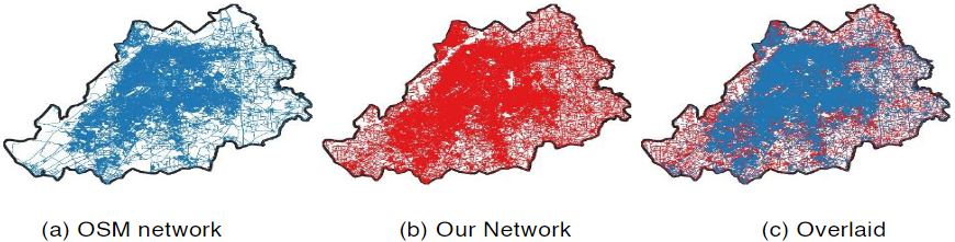
Figure 3: Comparison of coverage of OSM and our road network. The black boundary represents the spatial extent of district of Lahore.
4.2 Roads Classification
Although the OSM utilizes a consistent road classification scheme for the entire world, the structure of roads varies by region, therefore different countries use distinct road categorization schemes. The table 1 lists the various classification categories used around the world. OSM, on the other hand, uses entirely different categories: bridleway, construction, corridor, cycleway, footway, living street, motorway, motorway link, path, pedestrian, primary, primary link, residential, road, secondary, secondary link, service, steps, tertiary, tertiary link, track, trunk, trunk link, and unclassified. The detail of each of these categories can be found here.
In our network, we used the road classification offered by Pakis tan’s National Transport Research Center (NTRC). The NTRC classification scheme is outlined in the table 2.
5 Attributes of Our Road Network
Attributes of a road network are the properties associated with each road segment. There are no fix attributes, and they vary between different road networks. The detail of the attributes in our road network is given below.
- Class: The class of each road is stored in this attribute. The potential values for this attribute are shown in 2. The figure 4 shows our road

Table 1: Road classification schemes used around the world network where each color represents a particular class.
- Type: This attribute helps to further classify the roads. It accepts one of the values listed below.
- Service Road (S)
- Round About (RA)
- Underpass (UP
- Overhead (OH)
Length: This attribute stores the length of each road segment in meters.
Lanes: The number of lanes in a road segment is contained in this feature. This attribute has three distinct values: 1, 2, and 3.
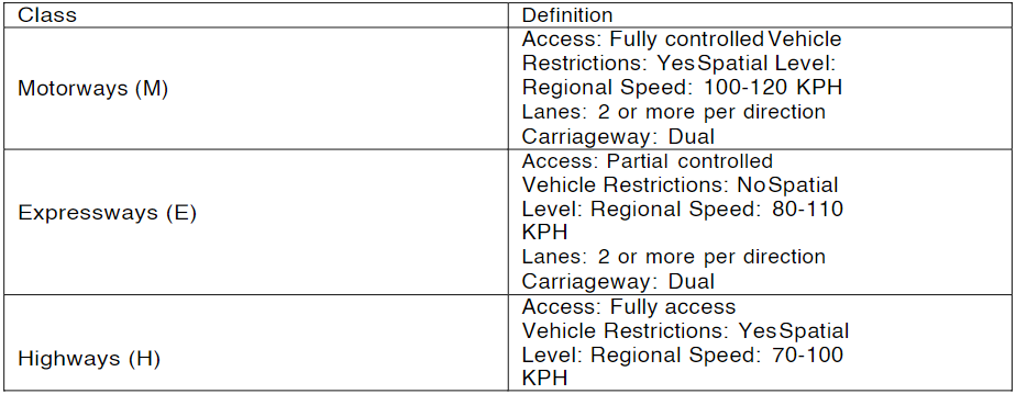
Table 2: NTRC Road classification Scheme
6 Conclusion
Road network is of great importance and can be used in variety of analysis and practical applications. Manually labelling a road network using aerial or satellite imagery is a time-consuming and labor- intensive process. We have devised a method for developing a road network that requires very little human input. We have developed and released the road network of Lahore so that researchers may benefit from it. On request, we can also create the road network for other areas. If someone is interested, please contact at tahir@lums.edu.pk with the subject “Request for Road Network”.